WORD ON THE STREET
News, Thoughts & Stories of Sustainable Ways of Getting Around

|
By Barry Remis (contributions by Andie Bridges) The months of January and February saw the completion of two milestone Active Transportation Program (ATP) projects in Goleta and Santa Barbara, and they both bring improved access and a safer route for area students to and from their schools. Here we celebrate the new Hollister Avenue Class I MultiUse Path and the even-newer Cota Street Buffered and Protected Bike Lane! A safer, off-the-road pathway along the Hollister Avenue corridor from Pacific Oaks Road to Ellwood Elementary School has long been a vision of the City of Goleta and area residents for cyclists and pedestrians young and old, as they walk or roll to and from school, parks and retail centers. With only a narrow sidewalk along the southern side of Hollister Ave., kids who rode their bikes to school had but two choices: either ride on the sidewalk or in the Class II bike lanes painted on the side of the 45-MPH roadway. Neither option was particularly safe. For years, the City needed a solution. Enter the Class I MultiUse Path: A 14-foot wide concrete bike/walkway—adjacent to the road on the ocean side—that is physically separated from the street by a 5-foot landscaped buffer. (Wherever possible, Class I separated bike paths are the preferred bikeway facility identified in the Goleta Bike/Ped Master Plan.) But unlike many other Class I Multipurpose paths where bicyclists and pedestrians share the same space, the Hollister Class I MutiUse Path is different. 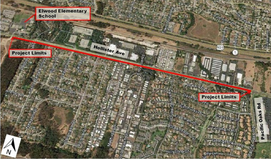 Here, the paved pathway is graphically delineated by two sections: a 4-foot pedestrian travel lane close to the road and bus stops, and an 8-foot bi-directional bike travel lane. A 2-foot shoulder is also provided to mark the edge of the right of way. At all intersections along the corridor, new high-visibility crosswalk treatments have been installed with colored patterns that continue the bike and pedestrian travel sections while crossing the street. New signage along the MultiUse path and on side streets advises motorists and path users to watch for crossing traffic and where on the path they should travel, and new stop signs have been installed for path users at every intersection. 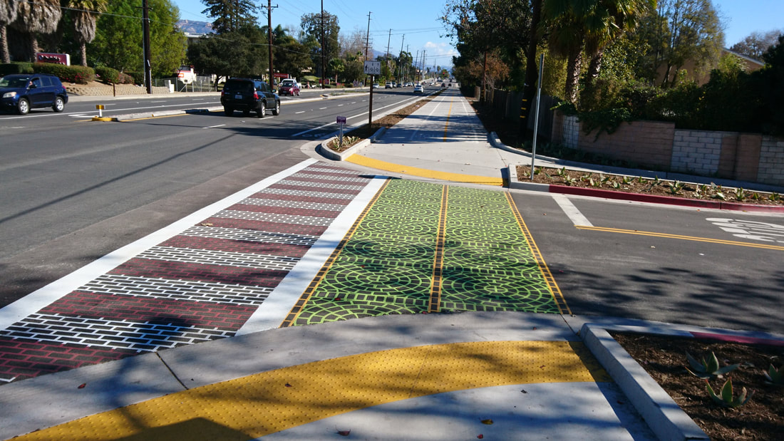 Green is for riders; red & white is for walkers only! The Hollister Class I MultiUse Path was constructed from May, 2017 thru January, 2018 using a $1.6 million ATP grant awarded from the state. Traffic along Hollister Ave. and side streets was disrupted and motorists’ patience was tested, but like all good projects, this was a temporary setback. Before the path striping, signage and crosswalk treatments were applied, residents had concerns regarding the safety of intersections and students traveling along the not-yet-completed pathway. There are still some final modifications needed, including removal of a few old utility poles in the middle of the bike travel lane, once wires are transferred (by Frontier Communications) to new poles placed off the pathway. Early in January, COAST’s Safe Routes to School team was pleased to partner with the City of Goleta and Ellwood School to provide educational training on the safe use of the MultiUse Path for all Ellwood students at every grade level. Safety presentations were followed by actual walks along the pathway for live, hands- (and feet-) on experience using the new path. On January 23rd, the City held a community meeting at Ellwood School where Public Works staff and COAST presented to the public and residents were able to ask questions and voice concerns. The project team took note of suggestions for future improvements. 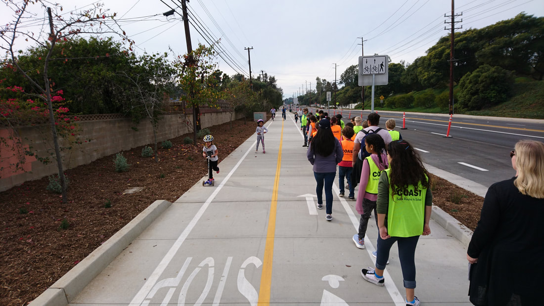 Ellwood 4th graders on a safety walk, as young ‘scooterers’ prepare for a stop. Just over a month in on the completed project and it’s evident that use of the Hollister Class I MultiUse Path is booming with more kids, parents, strollers, seniors and cyclists than ever before, enjoying the much-improved safety of this new Active Transportation facility! Ned Schoenwetter, Ellwood School Principal, notes that, in addition to helping promote health and safety, the path “is also strengthening our community, as neighbors walk and ride together.” And the path’s merits have already been recognized at high levels with the project recently being named ‘Santa Barbara County Project of the Year’ by the S.B./Ventura branch of ACSE (American Civil Service Engineers). While there remain opportunities for improvement, overall progress is notable. “It doesn’t have to be perfect to be remarkable,” said COAST Instructor Nancy Eckert. “This project is absolutely remarkable.” We encourage everyone to get out there and try out the Hollister MultiUse Path! Meanwhile, the 2016 update of Santa Barbara’s Bicycle Master Plan has officially spawned its very first project as Cota Street just received in February the City’s first Class IV Protected Bike Lane! Running one-way southbound along the West side of the street from Milpas to Chapala Streets, the new bike lane uses new striping and vertical delineators to create a ‘protected’ bike lane, buffered from motor vehicle traffic by a 2-3 foot divider marking, similar to the bike lane buffer on Bath Street, Meigs Road and Shoreline Drive. But what makes the new Cota bike lane stand apart from other S.B. bike lanes are the new cylindrical delineators placed every 25-30 feet from Milpas Street to Santa Barbara Street. These reflective vertical posts act as a physical divider so that cyclists not only have their own lane of travel, but can ride with an added sense of safety knowing they have that extra 3-dimensional buffer between them and motorists. The bike lane and delineators are not present in front of Santa Barbara Junior High School, where a 3-minute drop-off and pickup zone still exists for parents to load and unload students. 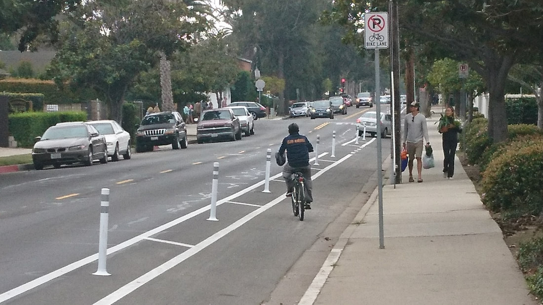 Like others in the Bicycle Master Plan Update, this project was not without contention. To accommodate the bike lane, many previous parking spaces were removed, and several stretches of curb are now painted red as no parking zones, while other spaces along Cota Street are now re-painted as 15-minute parking. Some loading zones along Cota have been shifted to now be on Olive Street, in front of Arnoldi’s Restaurant. This is undoubtedly an adaptation for many motorists and some business owners, but we believe it to be one for the better, providing a safe, convenient return-route of travel for SBJH students and other cyclists as a coupled pairing to the adjacent Haley Street bike lane. Along with new Class II bike lanes also just installed along Rancheria Street on the Westside, this is a big, bold step for the greater good of active, sustainable transportation in Santa Barbara. Check it out next time you ride!
0 Comments
|

 RSS Feed
